| Thanks to Ian Barr of Inverkip for Research & Presentation
INVERKIP INVERCLYDE SCOTLAND
Old Names :- “Auld Kirk”, “Innerkip”
Lat / Long :- 55 54.8′ N / 4 51.6′ W
Site & Situation
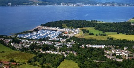
The village of Inverkip lies at the mouth of the river Kip, forming the easterncoastline of the firth of Clyde .
Originally Inverkip was seven miles in length E – W and six miles in breadth.
Much of the land away from the coastal strip consists of hill and upland , except for the valleys of the Kip and Daff rivers.
The climate is temperate and rain can be frequent and heavy but the sea air ensures that frost and snow seldom remain for long periods. The summer warmth is also moderated by these influences.
A Brief History
The history of Inverkip stretches back at least 830 years, what follows are the notable events during this period. In the year 1170 theSheriff of Lanark gave a grant of land to the monks of Paisley Abbey; the land was described as “The penny land between the rivulets Kip and Daff”.
The monks by 1188 had built a church on the site of the present old graveyard , this being a hundred years before William Wallace raised his standard against the English.
This church served the population from Kilmacolm to Largs for 400 years. In these heady days, Inverkip lay in the heartland of the Britons of Strathclyde. By 1301 a castle was built on Ardgowan Estate and in the year 1403 Sir John Shaw Stewart was given the Ardgowan land and castle; this family still own and run this estate and farms to this day.
Inverkip Auld Kirk ceased. In these days Inverkip was a rural district sustained by agriculture and fishing. Very little building had taken place apart from two rows of houses on either side of the main street stretching down to the shoreline.
In 1589 the Old West Kirk in Greenock opened and the great treks of the people to
A notorious claim to fame during this period was witchcraft. From 1640 – 1690 witch mania was rife; it is hard to imagine such a small area could be the center of this cult for 50 years.
The old manse Kirkbrae house was built in 1730 and the old post office came in 1732 the frontage at 64 Main street still exists.
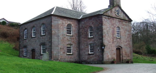
In 1798, the present Ardgowan house was built, and by 1803 the first proper road to Greenock was constructed by Sir John Shaw Stewart. The present church was completed in 1805 reputedly to a plan by the civil engineer Thomas Telford. The Loch Thom water supply system was completed in 1827 to supply Greenock. Loch Thom is only a few miles up behind the village and was considered a great engineering achievement in its’ day.
In 1836 the two roomed school was built on its present site in Station Road, the old original part of the school dates from that time. 1849 was a disastrous year, as the crops failed and one third of the population died of cholera. Inverkip during the late eighteenth century and early nineteenth century was noted for the frequent smuggling activities from the many passing vessels heading for the ports of Greenock and Port Glasgow. It is well documented that this occupied much of the time and effort of the customs men of the day.
In 1865 when the Glasgow – Wemyss Bay Caledonian Railway opened Inverkip changed from being a rural agricultural village , to being more of a seaside resort busy with trippers from Greenock to Glasgow. The local jetty from which Ferries tendered to the passing Paddle Steamers fell out of use and the steamer service stopped , goods and services then came by rail,and in 1867 Inverkip Railway Station was built. By 1900 a gas supply was piped to the village from Bankfoot a small farm area one mile outside the village, originally the Ardgowan Estate dairy unit.
The Cooperative Society came to Inverkip in 1919 and attracted 75% of the local trade. In 1920, the Daff reservoir was built behind the village to supply water to Gourock. Electricity came in 1932 fed from the Hydro in Skelmorlie. The mouth of the Kip was excavated in 1940 by the Army RE Unit to store barges (now the site of Inverkip Marina).
During this period Ardgowan House became a hospital and 28 houses were built and occupied by the army in Daff Avenue , just off the Main Street.
From 1951-1957 the County Council built the Crawford Lane and Glebe Road housing schemes. This development lies on the high ground behind the present church building. This provided much needed affordable , good housing to many of the local people.
By 1966 the last steam train gave way to diesel-electric and by 1973 the present marina was opened. At this time a road bypass was initiated to relieve the traffic congestion in the village.
The last large scale industrial development was the opening of Inverkip Power Station in 1979 , the stations’ main 600 foot chimney stack serves as a local landmark. Sadly the station is oil fired and was only used once during the miner’s strike of the 1980’s_ it has now been mothballed.
From the 1980’s on the village has seen many large private housing developments completed and many still under construction. The village now serves largely as a commuter district to Greenock and the major towns beyond.
Population : Since those distant times the village population has grown from 200 to approx 2000. If building continues at its’ present rate the old village will soon be considered a scattered township. |

